 South Hadley, Mass., about 90 miles west of Boston on the eastern bank of the Connecticut River, was once the site of the first commercially navigable canal in the United States. Built in the late 18th century, the South Hadley Canal stimulated the expansion of the western Massachusetts economy in the early decades of the 19th century.
Westward Expansion
After English settlers arrived in Plymouth Colony in 1620 and the Massachusetts Bay Colony (1629/30), further arrivals from both areas began to migrate to Windsor (1633) and Hartford (1638) in Connecticut Colony. Motivated by a desire for fertile land and the fur trade, settlers then continued to push northward along the Connecticut River. Along the way they established several agricultural communities in the 17th and 18th centuries that included South Hadley and Montague in Massachusetts.
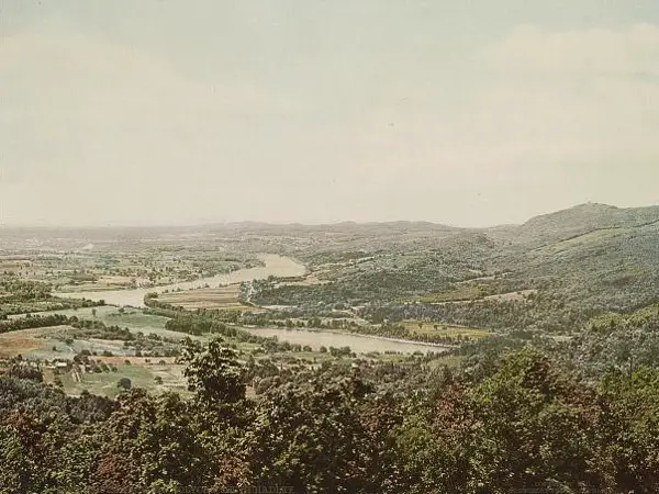
View of South Hadley from Mt. Holyoke
By 1790 these settlements had established trading relationships with regional and international markets as they moved away from subsistence economies. The principal exports of the settlers included agricultural goods (e.g., corn, grains), lumber, potash (e.g., for soap), and locally manufactured goods (e.g., brooms and tools). The settlers mainly sent their products to Hartford for transshipment to New York, Boston and Caribbean ports. In exchange the settlers received manufactured goods (e.g., textiles), some Hudson River goods (e.g., bricks) and West Indies commodities (e.g., molasses and coffee). However, as these exports moved down the southward flowing river by flatboat they encountered the Enfield Rapids above Hartford. This required goods to be unloaded and carried overland around the rapids and reloaded again. Not until 1829 did the Enfield Canal /Windsor Locks canal open to remove this obstacle.
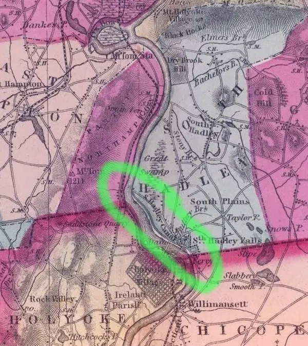
Map of South Hadley and environs, with the canal circled in green
Meanwhile, as goods moved upriver the flatboats had to confront a series of falls, beginning around South Hadley. That required a similar offloading of goods before resuming river travel. A group of investors, named “The Proprietors of the Locks and Canals on the Connecticut River,” sensed the area above South Hadley was sufficiently developed for further commercial gain. They therefore obtained a charter in 1792 to build canals at South Hadley and Turners Falls. Stock shares to local and Dutch investors would privately finance both canals.
Building the South Hadley Canal
Builders of the South Hadley Canal faced the daunting task of getting through hard rock terrain to bypass a 53- to 58-foot drop in the falls and its rapids over a 2.5 mile distance. They created a dam in the upstream end of the canal that allowed water to flow from the river into the canal to ensure navigation. To get the flatboats into the canal at the downstream (southern) end, they constructed an ingenious incline plane. Chains powered by two large waterwheels hauled the flatboats in a specialized cart up its ramp, 275 feet long and 20 feet wide. In less than 20 minutes, the cart discharged the flatboats into the canal. As returning flatboats arrived at the incline plane, the process of getting the flatboats back in the river was reversed.
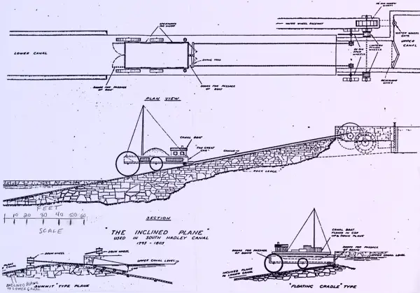
Inclined plane used in the South Hadley Canal
Despite the difficulties, the canal was built in about three years. It opened on April 16, 1795, the first commercially navigable canal in the United States. It could accommodate flatboats that measured 16 feet long and 40 feet wide. Revenue came from the tolls and, increasingly over time, from the sale of water rights for individual usage. In 1805, various locks replaced the incline plane as the canal was deepened. The first year of operation yielded only $3,109 in revenue. Nonetheless, the canal made a profit, especially after the first steamboat (The Barnet) began towing flatboats in the canal in 1826. It remained profitable until 1847 when railroads began offering a cheaper alternative for freight traffic. Still, the canal continued in operation until it closed in 1862.
A Sister to the South Hadley Canal
In 1794 some of the original investors who had signed the 1792 charter decided to form “The Proprietors of the Upper Locks and Canals on the Connecticut River.” They intended to build the Turners Falls (Montague) Canal, roughly 25 miles north of the South Hadley Canal. The investors felt that they needed separate funds for this difficult undertaking. The Turners Falls Canal was also about 2.5 miles long and 20 feet wide. It opened in 1798 with 10 locks, an impressive achievement that bypassed the “Great Falls” and its rapids. It alsobecame the second commercially navigable canal on the Connecticut River. The canal made a profit until, like the South Hadley Canal, the railroads began to take over its freight business. It closed for navigation in 1856.
Not only did these canals open up a cheaper and more efficient way to transport goods to wider markets, but they also stimulated industrial activity. At first, both canals powered grist and sawmills through water rights. However, only the South Hadley Canal would later grant water rights for larger paper and textile mills.
As the first commercially navigable canals, they also inspired the opening of canals in Vermont. These were canals at Bellows Falls (1802), Sumner Falls (1810) and White Pine/Wilder Falls/Olcott Falls (1811). Thus, the South Hadley Canal – along with the others on the Connecticut River – demonstrated that major river obstacles could be successfully overcome for economic advancement.
* **
 New from the New England Historical Society. A collection of stories about the Irish in New England. Click here to order your copy today!
Edward T. Howe, Ph.D. is Professor of Economics, Emeritus, at Siena University near Albany, N.Y.
Images: Seal of the proprietors By Holyoke Water Power Company – Canal Park Committee Records, Digital Commonwealth, CC BY 3.0, https://commons.wikimedia.org/w/index.php?curid=79954851. Featured image created by ChatGPT. South Hadley Detroit Publishing Co., Publisher, and Copyright Claimant Detroit Publishing Co. South from Mt. Holyoke, South Hadley. Massachusetts United States South Hadley, ca. 1900. Photograph. https://www.loc.gov/item/2016794237/.